

Weitere Abbildung
376
Pazifik
1 Bl. Mer du Sud ou Pacifique (P. Mortier). - Dabei: 1 Bl. Japon (La Perouse). Zus. 2 Bll., 1700.
Kolor. Kupferstich
Schätzung:
€ 800 Ergebnis:
€ 768 (inkl. Käuferaufgeld)
Pazifik. - Mortier.
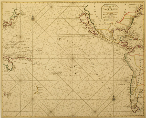
Mer de Sud, ou Pacifique, contenant l'isle de Californe, les Costes de Mexique, du Perou, Chili .. Amsterdam um 1700.
Großformatige Seekarte des Pazifik, von zwei Platten gedruckt und zusammengefügt. Das dargestellte Gebiet erstreckt sich zwischen Japan, Neu-Guinea und Australien (mit angedeuteter Küstenlinie) im Westen, und fast dem gesamten Nordamerika (mit Kalifornien als Insel) sowie der Westküste Südamerikas im Osten. Basierend auf Mortiers eigener Weltkarte (1693), nach 1700 nicht mehr nachgedruckt. "Unlike many of its counterparts this map appears to have a short life, being found only in the two editions of the Neptune François in 1700." - In den breiten Rändern gering fleckig, unt. rechte Ecke mit leichter Knickspur und außerhalb des Kartenbildes mit Numerierung von alter Hand. - 1 Beigabe.
EINBAND: 60,5 : 75,5 cm. - ILLUSTRATIONEN: Grenzkolor. Kupferstich bei P. Mortier,
LITERATUR: McLaughlin/M. 137. - Burden II, 770. - Tooley, America S. 127, 64.
Rare sea chart of the Pacific in outline coloring, depicting Japan, part of the coastlines of New Guinea and Australia and most of North and South America (with California as an island). Modelled after Mortier's own world map 1693, but apparently not reissued in one of his atlases after 1700. - Printed from two plates and joined. Only here and there stained in the broad margins, lower right corner with slight crease and numbering by and old hand. - 1 additional map.
Weitere Informationen
Empfehlen
 +Link zum Teilen
+Link zum Teilen
376
Pazifik
1 Bl. Mer du Sud ou Pacifique (P. Mortier). - Dabei: 1 Bl. Japon (La Perouse). Zus. 2 Bll., 1700.
Kolor. Kupferstich
Schätzung:
€ 800 Ergebnis:
€ 768 (inkl. Käuferaufgeld)
Weitere Informationen
Empfehlen
+Link zum Teilen
+Link zum Teilen

Ihre Lieblingskünstler im Blick!
- Neue Angebote sofort per E-Mail erhalten
- Exklusive Informationen zu kommenden Auktionen und Veranstaltungen
- Kostenlos und unverbindlich