

166
Vincenzo Maria Coronelli
Memoires historiques & geographies du royaume de la Morée, 1686.
Schätzung:
€ 1.000 Ergebnis:
€ 826 (inklusive Aufgeld)
166
Vincenzo Maria Coronelli
Memoires historiques & geographies du royaume de la Morée, 1686.
Schätzung:
€ 1.000 Ergebnis:
€ 826 (inklusive Aufgeld)
Vincenzo Maria Coronelli
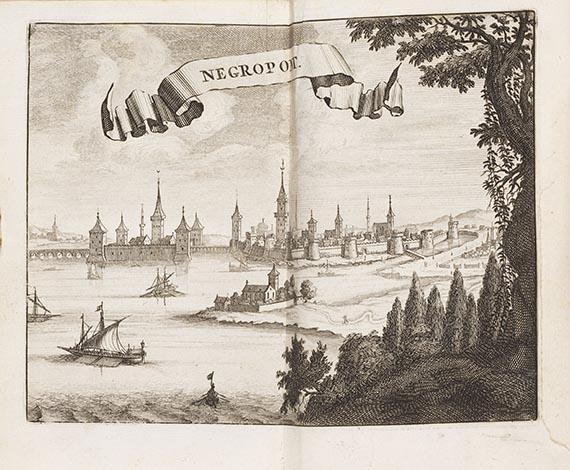
Memoires historiques & geographies du royaume de la Moree, Negrepont & des places maritimes, jusques à Thessalonique. Traduit de l'Italien. Amsterdam, Wolfgang u. a. 1686.
Erstmals 1685 erschienene geschichtliche und geographische Beschreibung des Peloponnes und der griechischen Inseln, die innerhalb kurzer Zeit in mehrere europäischen Sprachen übersetzt wurde.
Erste Amsterdamer Ausgabe. "This is a new translation produced for the Dutch booksellers and not simply a reprint of the French translation by Barbin." (Blackmer) - "The most outstanding example of the genre of traveller's description .. includes many placenames, ancient and contemporary, historical elaborations and plans" (Maps and Mapmakers of the Aegean, S. 30). - Die Kupfertafeln mit Stadtansichten, Plänen von Festungen, Schlachtendarstellungen und Karten.
EINBAND: Pergamentband d. Zt. mit etw. Rückenvergoldung. 15,5 : 10 cm. - ILLUSTRATION: Mit 42 Kupfertafeln und -karten. - KOLLATION: 2 Bll., 232 S., 1 Bl. - ZUSTAND: Vereinz. fleckig, 4 Taf. mit Randausrissen entlang der Plattenkante, 1 Taf. mit Falzeinriß, 1 Taf. mit kl. Loch im Bundsteg. Kanten tls. etw. beschabt.
LITERATUR: Blackmer 407. - Nederl. Scheepvaart-Mus. I, 193.
First Dutch edition, printed in French. With 42 engr. plates. Contemp. vellum. - Occasionally stained, 4 plates with partly torn-off margins along the platemark, 1 plates with split to fold, 1 plate with small hole in the gutter. Edges partly scraped.


Ihre Lieblingskünstler im Blick!
- Neue Angebote sofort per E-Mail erhalten
- Exklusive Informationen zu kommenden Auktionen und Veranstaltungen
- Kostenlos und unverbindlich