

Weitere Abbildung
Weitere Abbildung
Weitere Abbildung
Weitere Abbildung
28
Jacob Ziegler
Quae intus continentur. Syria ... Schondia, Holmiae regionem, 1532.
Schätzung:
€ 10.000 Ergebnis:
€ 23.750 (inkl. Käuferaufgeld)
28
Jacob Ziegler
Quae intus continentur. Syria ... Schondia, Holmiae regionem, 1532.
Schätzung:
€ 10.000 Ergebnis:
€ 23.750 (inkl. Käuferaufgeld)
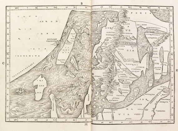
Finnlands erste Karte
Jakob Ziegler
Quae intus continentur. Syria. Palestina. Arabia. Aegyptus. Schondia. Holmiae. Regionum superiorum, singulae tabulae geographicae. Straßburg, Peter Schöffer d. J., 1532.
- Bedeutende Geographie Palästinas und Skandinaviens
- Seltene Erstausgabe
- Prachtvoller Antiqua-Druck mit Holzschnitt-Karten
- Mit der ersten authentischen Karte Skandinaviens
"Die Ziegler-Karten gehören, trotz einiger Irrtümer und Ungereimtheiten, zu den Marksteinen der Palästina-Kartographie" (Loewenhardt)
Sehr schöner, sauberer und breitrandiger Druck mit prächtigen Holzschnittkarten von Syrien mit Zypern, Palästina, Arabien und Ägypten. Ferner mit der wertvollen Karte der skandinavischen Länder, die hier erstmals relativ authentisch dargestellt werden und in Nord-Süd-Richtung ausgerichtet sind. Zudem findet sich zum ersten Mal in der Geschichte der Kartographie der Name Finnlands ("Finlandia") auf einer gedruckten Karte.
EINBAND: Neuer Halbmaroquinband mit Rückenvergoldung. Folio. 28,5 : 19,5 cm. - ILLUSTRATION: Mit 8 doppelblattgroßen Holzschnitt-Karten (auf 16 nn. Bll.) und einigen Holzschnitt-Diagrammen im Text. - KOLLATION: 110 (recte 116) röm. num., 18 nn. Bll. - ZUSTAND: Sehr gut erhalten.
LITERATUR: VD 16, Z 448. - Adams Z 153. - Sabin 106.331. - Alden/Landis 536/22. - Loewenhardt S. 72ff.
First edition. Rare geographical work on the near and middle East and Scandinavia. With 8 double-page woodcut maps, the final of which depicting Scandinavia in a relatively correct shape. The map sets up a new standard after the Ulm map 1482 and is a key map in the history of cartography of the North. For the first time the axis of Scandinavia is running north-south. The peninsula of Finland is not only distinctly depicted by Ziegler but the name Finland ("Finlandia") is for the first time introduced on a printed map. Furthermore Scandinavia is connected to Greenland "upon which is identified to the south 'Terra Bacallaos', or the land of codfish, which represents the area of Newfoundland" (Burden). Mod. half morocco with gilt title on spine. - Very well-preserved copy with wide margins.(R)
Weitere Informationen
Empfehlen
 >Link zum Teilen
>Link zum Teilen

Ihre Lieblingskünstler im Blick!
- Neue Angebote sofort per E-Mail erhalten
- Exklusive Informationen zu kommenden Auktionen und Veranstaltungen
- Kostenlos und unverbindlich