

Weitere Abbildung
Weitere Abbildung
Weitere Abbildung
20
James Cook
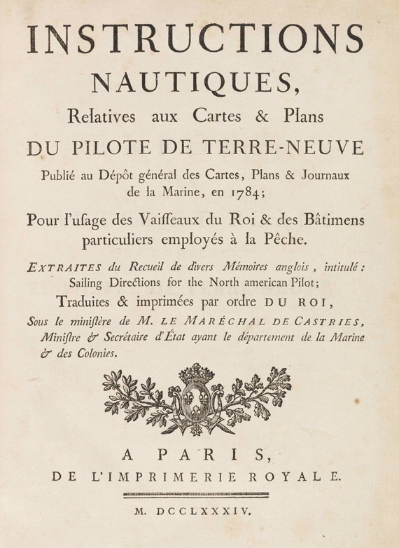
Le Pilote de Terre-Neuve. Atlas und Textbd. "Instructions nautiques", zus. 2 Bände, 1784.
Schätzung:
€ 8.000 Ergebnis:
€ 7.500 (inkl. Käuferaufgeld)
Die Kartographierung Neufundlands
James Cook u. a.
Le Pilote de Terre-Neuve ou recueil de plans des côtes et des ports de cette île. - Instructions nautiques, relatives aux cartes & plans du pilote de terre-neuve. Atlas- und Textband. Paris, Depot de la Marine 1784.
- Atlas von Neufundland und Labrador mit den Karten von James Cook
- Vollständiges Exemplar mit dem raren Textband
- Von großer Seltenheit
Erste französische Ausgabe. Sehr seltenes Exemplar des Atlas mit dem erläuternden Textband Instructions nautiques ("five tracts, each with separate signatures and pagination", Tooley S. 202). - Nach Ende des Siebenjährigen Krieges 1763 wurde Cook von der Admiralität beauftragt, die neuen britischen Provinzen Neufundland und Labrador kartographisch zu erfassen. Das Ergebnis seiner beispielhaft präzisen Vermessungsarbeiten 1763-67 galt für mehr als 100 Jahre als maßgeblich für die kartographische Darstellung der Gegend. - Exemplar mit der zusätzlichen, im Tafelverzeichnis nicht aufgeführten Karte Plan de la Baye de St. Lunaire. - Die ersten 9 Karten von James Cook nach der englischen Ausgabe The North-Atlantic Pilot for Newfoundland (1775), 2 Karten stammen von Fortin (datiert 1763-1782) und die letzte Karte von Grandchain (datiert 1784-85).
EINBAND: Halblederband der Zeit mit reicher Rückengoldprägung und altem rotem Deckelschild auf erneuerten Bezugspapieren (Atlas, 67 : 52,5 cm) und Lederband der Zeit mit Rückenvergoldung und -schild sowie goldgepr. Deckelfilete (Textband, 25,5 : 20 cm). - ILLUSTRATION: Mit gestochenem Titel (mit Tafelverzeichnis) und 12 gestochenen Karten (10 doppelblattgroß). - KOLLATION: 2 Bll., XXIV; 80 S.; 26 S.; 32 S.; 28 S. - ZUSTAND: Textband leicht stockfleckig, wenige Bll. stärker, Karten des Atlas neu angefalzt, insgesamt sehr sauber und auf kräftigen Bütten. Gelenke und Kapitale des Textbandes restauriert.
LITERATUR: Tooley, America S. 201 und 202. - Phillips/Le Gear 4490 (Atlas).
First French edition. Very scarce. Complete copy with atlas and text volume. With engr. title with index of plates and 12 mostly doublepage engr. maps (9 by James Cook, 2 by Fortin and the last one "Plan de la Baye de St. Lunaire" by Grandchain, which is extra and not listed on the index; cf. Tooley, Mapping of America p. 201). Atlas bound in contemp. half calf with rich gilt decoration on spine and label on front board (covering paper renewed), text in contemp. calf binding with gilt decoration and label on spine (text vol.). - Text vol. slightly foxed, few leaves stronger, maps in atlas mounted on new guards. Joints and extremities of spine of text vol. restored. Overall very clean copy of the atlas with the detailed maps printed on strong laid paper.R)

20
James Cook
Le Pilote de Terre-Neuve. Atlas und Textbd. "Instructions nautiques", zus. 2 Bände, 1784.
Schätzung:
€ 8.000 Ergebnis:
€ 7.500 (inkl. Käuferaufgeld)